


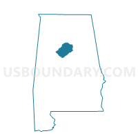
Oak Grove First Baptist Church, Jefferson County, Alabama
About
Outline

Summary
| Unique Area Identifier | 522136 |
| Name | Oak Grove First Baptist Church |
| County | Jefferson County |
| State | Alabama |
| Area (square miles) | 85.99 |
| Land Area (square miles) | 83.22 |
| Water Area (square miles) | 2.77 |
| % of Land Area | 96.78 |
| % of Water Area | 3.22 |
| Latitude of the Internal Point | 33.42276470 |
| Longtitude of the Internal Point | -87.20972980 |
Maps


Graphs
Select a template below for downloading or customizing gragh for Oak Grove First Baptist Church, Jefferson County, Alabama


Neighbors
Neighoring Voting District (by Name) Neighboring Voting District on the Map
- Abernant Masonic Lodge-Bucksville, Tuscaloosa County, AL
- Alliance Community Center, Jefferson County, AL
- Brookwood City Hall-Kellerman, Tuscaloosa County, AL
- Concord Highland Baptist Church, Jefferson County, AL
- Johns Community Center, Jefferson County, AL
- Pleasant Hill United Methodist Church, Jefferson County, AL
- Tutwiler Fire Dept, Walker County, AL
- Windham Springs Baptist Church, Tuscaloosa County, AL
Top 10 Neighboring County Subdivision (by Population) Neighboring County Subdivision on the Map
- Abernant CCD, Tuscaloosa County, AL (9,955)
- Concord-Rock Creek CCD, Jefferson County, AL (7,667)
- North Johns CCD, Jefferson County, AL (4,918)
- Brookwood CCD, Tuscaloosa County, AL (4,520)
- West Jefferson CCD, Jefferson County, AL (4,160)
- Maytown-Sylvan Springs CCD, Jefferson County, AL (3,829)
- Oakman CCD, Walker County, AL (3,557)
- Windham Springs CCD, Tuscaloosa County, AL (3,083)
Top 10 Neighboring Unified School District (by Population) Neighboring Unified School District on the Map
- Jefferson County School District, AL (230,679)
- Tuscaloosa County School District, AL (105,218)
- Walker County School District, AL (52,671)
Top 10 Neighboring State Legislative District Lower Chamber (by Population) Neighboring State Legislative District Lower Chamber on the Map
- State House District 62, AL (55,022)
- State House District 15, AL (48,965)
- State House District 56, AL (41,064)
- State House District 14, AL (40,597)
Top 10 Neighboring State Legislative District Upper Chamber (by Population) Neighboring State Legislative District Upper Chamber on the Map
- State Senate District 14, AL (168,669)
- State Senate District 21, AL (140,682)
- State Senate District 5, AL (134,976)
Top 10 Neighboring 111th Congressional District (by Population) Neighboring 111th Congressional District on the Map
- Congressional District 6, AL (754,482)
- Congressional District 4, AL (660,162)
- Congressional District 7, AL (603,352)
Top 10 Neighboring Census Tract (by Population) Neighboring Census Tract on the Map
- Census Tract 106.02, Tuscaloosa County, AL (9,955)
- Census Tract 141.02, Jefferson County, AL (4,918)
- Census Tract 106.01, Tuscaloosa County, AL (4,520)
- Census Tract 122, Jefferson County, AL (4,160)
- Census Tract 140.01, Jefferson County, AL (4,011)
- Census Tract 123.02, Jefferson County, AL (3,829)
- Census Tract 213, Walker County, AL (3,557)
- Census Tract 101.02, Tuscaloosa County, AL (3,083)
Top 10 Neighboring 5-Digit ZIP Code Tabulation Area (by Population) Neighboring 5-Digit ZIP Code Tabulation Area on the Map
- 35023, AL (25,436)
- 35475, AL (14,507)
- 35580, AL (3,791)
- 35444, AL (3,699)
- 35579, AL (3,136)
- 35006, AL (3,121)